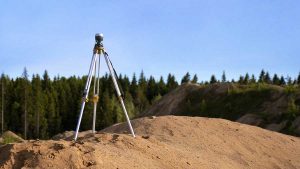
Land surveys are an essential part of property ownership, development, and construction. Whether you are buying land, planning to build, or resolving a boundary issue, the right survey provides clarity...
Read More
The Rise of Drone Land Surveying
- August 26, 2025
- MGA Admin
- 3:23 pm
In recent years, drones have transformed many industries—from photography to agriculture—and land surveying is no exception. Once limited to ground-based instruments and manual measurements, modern surveyors are now embracing unmanned aerial vehicles (UAVs), or drones, to capture data faster, safer, and more accurately than ever before.
How Drone Land Surveying Works
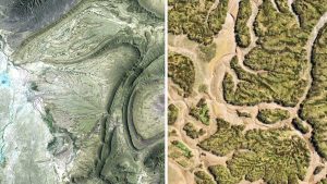
Drone surveying uses UAVs equipped with high-resolution cameras, GPS, and sometimes LiDAR (Light Detection and Ranging) sensors to collect aerial imagery and elevation data. This information is processed into detailed maps, 3D models, and contour lines that surveyors can analyze and certify.
Instead of spending days walking a site with traditional equipment, surveyors can now cover large areas in a fraction of the time—often within hours.
Benefits of Drone Surveying
- Speed and Efficiency – Drones can map hundreds of acres in a single flight, reducing project timelines.
- Accuracy – With GPS and advanced sensors, drones can achieve centimeter-level precision when combined with ground control points.
- Safety – Surveyors can avoid hazardous terrain, steep slopes, or busy construction zones by sending a drone instead of working directly in those environments.
- Cost Savings – Faster data collection means reduced labor costs and fewer site visits.
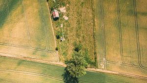
- Versatility – Drones can be used for topographic surveys, construction progress monitoring, volumetric measurements (like stockpiles), floodplain mapping, and more.
Applications in North Carolina and Beyond
In North Carolina, where urban growth, infrastructure improvements, and agricultural development are constant, drone surveying is becoming an essential tool. Surveyors are using drones to:
- Support highway and bridge projects
- Measure farmland and forestry tracts
- Assist developers with subdivision planning
- Monitor erosion in coastal and flood-prone areas
Challenges and Regulations
While drones offer clear advantages, their use in surveying must comply with regulations. In the U.S., surveyors must follow FAA Part 107 rules for commercial drone operations, which cover pilot licensing, flight restrictions, and airspace regulations. Importantly, in North Carolina, only a licensed Professional Land Surveyor (PLS) can certify and sign off on official survey documents.
The Future of Surveying
Drone technology is still evolving, with new advancements in LiDAR, real-time kinematic (RTK) GPS, and artificial intelligence promising even greater precision. As regulations adapt and equipment improves, drones will likely become a standard tool in nearly every surveyor’s toolkit.
Final Thoughts
The rise of drone land surveying represents a powerful blend of tradition and innovation. While drones don’t replace the expertise and legal authority of a licensed surveyor, they enhance the profession by providing faster, safer, and more accurate data. For property owners, developers, and communities across North Carolina, this means better information and smarter decisions about the land we live on.
References
- Federal Aviation Administration (FAA) – Part 107 Drone Rules
- North Carolina Board of Examiners for Engineers and Surveyors (NCBELS) – https://www.ncbels.org