
Land surveys are an essential part of property ownership, development, and construction. Whether you are buying land, planning to build, or resolving a boundary issue, the right survey provides clarity...
Read More
Advanced Technologies That Are Transforming Land Surveying
- August 26, 2025
- MGA Admin
- 4:00 pm
Land surveying has always been about precision—measuring, mapping, and documenting the land to guide development, protect property rights, and support infrastructure. While the fundamentals remain the same, today’s surveyors are using cutting-edge technology that makes their work faster, safer, and more accurate than ever before. From satellites in space to drones in the sky, here’s a look at some of the advanced technologies shaping the future of land surveying.
1. Global Navigation Satellite Systems (GNSS)
Modern surveyors use GNSS (including GPS in the United States, GLONASS in Russia, and Galileo in Europe) to pinpoint locations with incredible accuracy. Equipped with real-time kinematic (RTK) technology, surveyors can measure property boundaries and construction layouts down to the centimeter.
Benefits: Fast data collection, global coverage, and compatibility with digital mapping software.
Applications: Boundary surveys, construction staking, infrastructure projects.
2. Drones (UAVs) and Aerial Imaging
Drones equipped with high-resolution cameras and sensors allow surveyors to capture aerial imagery and create 3D site models in hours rather than days. They are particularly valuable for surveying large or hard-to-access areas.
Benefits: Speed, safety, and cost savings.
Applications: Topographic mapping, construction progress monitoring, floodplain assessments, agricultural land surveys.
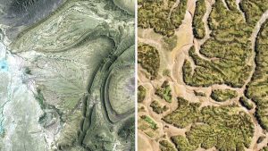
3. LiDAR (Light Detection and Ranging)
LiDAR uses laser pulses to measure distances and generate highly accurate 3D models of terrain. Unlike traditional cameras, LiDAR can “see through” vegetation to capture bare-earth data.
Benefits: Exceptional accuracy, ability to penetrate tree canopy, effective in low-light conditions.
Applications: Floodplain studies, forestry management, transportation corridors, environmental monitoring.
4. 3D Laser Scanning
Also called terrestrial laser scanning, this technology captures millions of data points per second to create detailed 3D models of buildings, bridges, and infrastructure. It provides unmatched accuracy for documenting complex structures.
Benefits: High-detail models, rapid capture of existing conditions.
Applications: As-built surveys, historic preservation, industrial site surveys.
5. Geographic Information Systems (GIS)
GIS integrates survey data with maps, satellite imagery, and databases to create powerful tools for analysis and planning. Surveyors use GIS to overlay boundaries, utilities, and environmental data for more informed decision-making.
Benefits: Centralized data management and easy visualization.
Applications: Land development planning, municipal infrastructure, environmental studies.
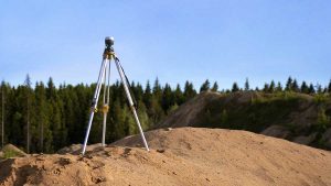
6. Robotic Total Stations
Unlike traditional total stations that require two operators, robotic total stations can be operated by a single surveyor using remote control. These instruments measure angles, distances, and elevations with exceptional precision.
Benefits: Improved efficiency, reduced labor costs.
Applications: Construction staking, large-scale development surveys.
7. Artificial Intelligence (AI) and Data Processing
Surveying produces massive amounts of data, and AI is helping professionals analyze it faster. Automated software can classify LiDAR point clouds, detect changes in terrain, and flag potential errors.
Benefits: Faster processing and reduced human error.
Applications: Automated mapping, environmental monitoring, smart city development.
Advanced technologies are not replacing the expertise of professional land surveyors—they are enhancing it. From GNSS and drones to LiDAR and AI, these tools allow surveyors to deliver more accurate results in less time, ultimately benefiting property owners, developers, and communities. The future of surveying is a blend of time-tested knowledge and state-of-the-art innovation, ensuring that every project is built on a foundation of precision.
References
- American Society for Photogrammetry and Remote Sensing (ASPRS): https://www.asprs.org
- National Society of Professional Surveyors (NSPS): https://nsps.us.com
- Federal Aviation Administration (FAA) – Drone Regulations